Activities

Première entreprise touristique qui a reçu le certificat ISO 9001:2008
...tout montrer...
Vous êtes ici: Initiation » Marches » Randonee Cedros - Ulta
RANDONEE CEDROS – ULTA
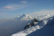
Spectaculaire périple entre les sommets enneigés qui permettent de contempler les montagnes du secteur nord du Parc Nacional Huascarán, où vous trouverez d'énormes glaciers, lacs aux couleurs magnifiques, une riche variété de la flore et de la faune andine, tout cela dans la cordillère tropicale la plus haute du monde.
Venez et profitez de ce magnifique spectacle, unique au monde.
Cedros - Ulta 12 jours
Durée: 12 Jous
Mois: Avril - Novembre
Difficulté: Moderate
Accès: Cashapampa
Sortie: Quebrada Ulta (retorno a Huaraz)
Altitude Minium: 2900m (Cashapampa)
Altitude Maximum: 4767m (Portachuelo)
ITINÉRAIRE
| Jour 1 |
Huaraz - Cashapampa – Hualcayan |
| Jour 2 |
Hualcayan – Huishcash |
| Jour 3 |
Huishcash - Paso gallo Huacanan - Paso Jatun vientona - Ruina pampa |
| Jour 4 |
Ruina pampa - Jancarurish |
| Jour 5 |
Jancarurish – Paso Q'ara Q'ara – Huillcapampa |
| Jour 6 |
Huillcapampa - Paso Pucajirca – Jancapampa |
| Jour 7 |
Jancapampa – Paso Tupa tupa - Laguna Huecroncocha |
| Jour 8 |
Dia de descanzo Huecroncocha |
| Jour 9 |
Huecroncocha – Alto of Pucaraju - Cachina pampa |
| Jour 10 |
Cachina pampa – Colcabamba – Mirador |
| Jour 11 |
Mirador – Avalancha – Paso of Yana yacu – Laguna Yana yacu |
| Jour 12 |
Laguna Yana yacu – Ulta – Huaraz |

« Return
SOUTH OF HUARAZ
Chavín de Huántar archaeological site
Geographic Location
Chavín is located at the beginning of a narrow valley formed by the Pukcha or Mosna River, which originates from the melt water of the Cordillera Blanca and runs down to the Marañón River, one of the tributaries of the Amazon.
It lies in the heart of the Andes at 3180 meters above sea level, forming part of the so-called Callejón de Conchucos that runs from south to north. Two mountain ranges, the Cordilleras Blanca and Negra, separate Chavín from the ocean and two other chains separate it from the Amazon jungle. The central one rises between the Marañón and Huallaga drainages and the eastern one separates the waters of the Huallaga and Ucayali rivers. This geographic situation creates a series of difficulties for communication among resident human populations, whose relative proximity is mediated by the altitude and the irregularity of the terrain.
This is the birthplace of early civilization. A visitor leaving Chavín de Huántar may feel a complex sensation that is a mixture of emotion, stupor and magic, not only for having come in contact with one of the most powerful and sensitive archaeological centers, but also because Chavín is capable of transmitting a unique vision of our identity, history and strengths.
As great and imposing as Machu Picchu, Chavín de Huántar is an archaeological complex built by the Chavín culture more than three thousand years ago. Declared to be a world heritage site by UNESCO in 1985, the monument is composed of impressive stone constructions with enigmatic interior galleries. Its stone carvings consist of tenoned heads, incised stone slabs and hydraulic canals. The enigmatic Lanzón shows fine technique, a heightened aesthetic sense and, above all, a refined sense of cult and spirituality.

 Situation géographique de nos montagnes enneigées et sommets
 Paquetes de visita al Parque Nacional Huascaran
 Jr. Pedro Cochachin 357, Huaraz - Peru
 Email: ventas@turismoandino.com.pe
 Téléphone: (0051) 43 - 421662


