Activities

Première entreprise touristique qui a reçu le certificat ISO 9001:2008
...tout montrer...
Vous êtes ici: Initiation » Marches » Huayhuash Trek
HUAYHUASH TREK
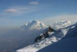
Huayhuash est situé au sud-est de la Cordillère Blanche et s'étend sur 30 kilomètres suivant une orientation nord – sud. Toutefois, sept de ses sommets dépassent les 6000 mètres d'altitude et sept autres dépassent les 5500 mètres. Le plus important de ces sommets est sans doute le Yerupajá (6634 mètres), le deuxième le plus haut du Pérou et le sommet le plus haut du vaste bassin amazonique. D'autres pics importants dans la région sont le Rondoy (5879 mètres), Jirishanca (6094 mètres), Yerupajá chico (6121 mètres) ainsi que celui connu commu le taureau, Siulá grande (6356 mètres), Sarapo (5975 mètres), Carnicero (5975 mètres) et Trapecio (5644 mètres).
Le paysage aux alentours de Huayhuash a tendance à être ample, a peu de vallées étroites qui en principe caractérisent la Cordillère Blanche. Son flanc oriental est une vaste région de collines couvertes de prairies naturelles, avec des parois rocheuses escarpées qui émèrgent jusqu'à 6000 mètres. De belles lagunes couleur émeraude et peuplées de truites se situent au pied de plusieurs glaciers.
Huayhuash représente un exemple extraordinaire de ce que peut être un écosystème andin de haute montagne. Sa flore et sa faune sont similaires à celles existantes dans la Cordillère Blanche, mais moins
endommagées par l'homme et concentrés en un ample rang d'écosystèmes répartis sur des sections réduites de terrain. Les lacs abritent de nombreuses espèces d'oiseaux, tant migrateurs que résidents et les forêts de queñual du flanc occiental accueillent quelques-unes des espèces les plus rares des Andes. De petits troupeaux de vigognes insouciantes broûtent dans les vallées innacessibles.
Huayhuash 6 jours
Durée: 6 jours
Mois: Avril - Novembre
Difficulté: Moderate
Accès: La Unión / Queropalca
Sortie: Cajatambo / Barranca
Altitude Minium: 3300m (Llamac)
Altitude Maximum: 4750m (Portachuelo)
ITINÉRAIRE
| Jour 1 |
Huaraz – Queropalca |
| Jour 2 |
Queropalca – Laguna de Carhuacocha |
| Jour 3 |
Carhuacocha – Paso Siulá – Huayhuash |
| Jour 4 |
Huayhuash – Paso Portachuelo - Laguna Viconga |
| Jour 5 |
Laguna de Viconga - Quebrada Pumarinri (4000m) |
| Jour 6 |
Quebrada Pumarinri – Cajatambo (3375m) |

Huayhuash 7 jours
Durée: 7 jours
Mois: Avril - Novembre
Difficulté: Moderate
ITINÉRAIRE
| Jour 1 |
Huaraz - Llamac - Cuartelhuain |
| Jour 2 |
Cuartelhuain – Paso Cacananpunta – Laguna of Mitucocha |
| Jour 3 |
Mitucocha – Paso Carhuac Punta – Laguna of Carhuacocha |
| Jour 4 |
Carhuacocha – Col Punta Carnicero - Huayhuash |
| Jour 5 |
Huayhuash – Paso Portachuelo - Laguna Viconga |
| Jour 6 |
Laguna of Viconga- Quebrada Pumarinri |
| Jour 7 |
Quebrada Pumarinri– Cajatambo – Barranca |
Huayhuash 8 jours
Durée: 8 jours
Mois: Avril - Novembre
Difficulté: Moderate
Accès: La Unión / Queropalca
Sortie: Cajatambo / Barranca
Altitude Minium: 3300m (Llamac)
Altitude Maximum: 4750m (Portachuelo)
ITINÉRAIRE
| Jour 1 |
Huaraz – Queropalca |
| Jour 2 |
Queropalca – Laguna de Carhuacocha |
| Jour 3 |
Descanso en Carhuacocha |
| Jour 4 |
Carhuacocha – Paso de Carhuac Punta - Laguna de Mitucocha |
| Jour 5 |
Laguna de Mitucocha – Col de Cacananpunta – Matacancha |
| Jour 6 |
Matacancha – Col de Sambuya - Laguna Jahuacocha |
| Jour 7 |
Descanso en Jahuacocha |
| Jour 8 |
Laguna de Jahuacocha - Pampa Llamac - Llamac - Huaraz |
Huayhuash 11 jours - Route 1
Durée: 11 jours
Mois: Avril - Novembre
Difficulté: Moderate
Accès: La Unión / Huallanca
Sortie: Llamac / Huaraz
Altitude Minium: 3300m (Llamac)
Altitude Maximum: 5000 (Paso Cuyoc)
ITINÉRAIRE
| Jour 1 |
Huaraz – Paso Cuncush – Cuartelhuain |
| Jour 2 |
Cuartelhuain- Cacananpunta – Laguna of Mitucocha |
| Jour 3 |
Laguna of Mitucocha – Paso Carhuacpunta -Laguna of Carhuacocha |
| Jour 4 |
Descanso en Carhuacocha |
| Jour 5 |
Laguna of Carhuacocha – Paso Punta carnicero – Huayhuash |
| Jour 6 |
Huayhuash- Portachuelo of Huayhuash – Viconga |
| Jour 7 |
Viconga – Punta Cuyoc – Guanacpatay |
| Jour 8 |
Guanacpatay – Huayllapa - Huatiac |
| Jour 9 |
Huatiac-Punta Tapush – Punta Yaucha - laguna of Jahuacocha |
| Jour 10 |
Descanso en Jahuacocha |
| Jour 11 |
Jahuacocha - Pampa Llamac – Llamac - Huaraz |
Huayhuash 11 days - Route 2
Durée: 11 jours
Mois: Avril - Novembre
Difficulté: Moderate
Accès: La Unión / Huallanca
Sortie: Llamac / Huaraz
Altitude Mínima: 3300m (Llamac)
Altitude Maximum: 5000m (Paso Cuyoc)
ITINÉRAIRE
| Jour 1 |
Huaraz – Paso Cuncush – Cuartelhuain |
| Jour 2 |
Cuartelhuain- Cacananpunta – Laguna Mitucocha |
| Jour 3 |
Laguna Mitucocha – Paso Carhuacpunta - Laguna Carhuacocha |
| Jour 4 |
Laguna Carhuacocha – Paso Siulá – Huayhuash |
| Jour 5 |
Huayhuash- Portachuelo of Huayhuash – Viconga |
| Jour 6 |
Viconga – Punta Cuyoc – Yanapampa |
| Jour 7 |
Yanapampa – Paso San Antonio – Laguna Jurao |
| Jour 8 |
Laguna Jurao – Huayllapa – Huatiac |
| Jour 9 |
Huatiac – Punta Tapush - Punta Yaucha – Laguna Jahuacocha |
| Jour 10 |
Descanso en Jahuacocha |
| Jour 11 |
Jahuacocha - Pampa Llamac – Llamac – Huaraz |
« Return
SOUTH OF HUARAZ
Chavín de Huántar archaeological site
Geographic Location
Chavín is located at the beginning of a narrow valley formed by the Pukcha or Mosna River, which originates from the melt water of the Cordillera Blanca and runs down to the Marañón River, one of the tributaries of the Amazon.
It lies in the heart of the Andes at 3180 meters above sea level, forming part of the so-called Callejón de Conchucos that runs from south to north. Two mountain ranges, the Cordilleras Blanca and Negra, separate Chavín from the ocean and two other chains separate it from the Amazon jungle. The central one rises between the Marañón and Huallaga drainages and the eastern one separates the waters of the Huallaga and Ucayali rivers. This geographic situation creates a series of difficulties for communication among resident human populations, whose relative proximity is mediated by the altitude and the irregularity of the terrain.
This is the birthplace of early civilization. A visitor leaving Chavín de Huántar may feel a complex sensation that is a mixture of emotion, stupor and magic, not only for having come in contact with one of the most powerful and sensitive archaeological centers, but also because Chavín is capable of transmitting a unique vision of our identity, history and strengths.
As great and imposing as Machu Picchu, Chavín de Huántar is an archaeological complex built by the Chavín culture more than three thousand years ago. Declared to be a world heritage site by UNESCO in 1985, the monument is composed of impressive stone constructions with enigmatic interior galleries. Its stone carvings consist of tenoned heads, incised stone slabs and hydraulic canals. The enigmatic Lanzón shows fine technique, a heightened aesthetic sense and, above all, a refined sense of cult and spirituality.

 Situation géographique de nos montagnes enneigées et sommets
 Paquetes de visita al Parque Nacional Huascaran
 Jr. Pedro Cochachin 357, Huaraz - Peru
 Email: ventas@turismoandino.com.pe
 Téléphone: (0051) 43 - 421662


